

Burt’s British Columbia / West Coast Tour
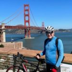
DAY 1 – Jul 12th – Vancouver, British Columbia
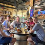
In case you haven’t heard, I’m doing a bicycle tour. Left on July 11th, flew to Vancouver, BC with the help of two friends, Pete Simons and Tom Hanson. Initial plan was to bike over Whistler, head northeast, up the Alaska Highway, maybe reach Fairbanks, down to Anchorage, etc., etc. That plan has changed just a bit. A few days before I left, many inland areas of BC are on fire. Go to plan B. Biking up Vancouver Island to Port Hardy, ferry to Prince Rupert, then biking east toward Prince George and up the Stewart Cassiar Highway. Lucky I’m flexible.
I arrived in Vancouver late at night, biked a little, took a train and stayed 2 nights with a wonderful family with a contact through “warmshowers”. Explored Vancouver the next day and got some bear spray and butane fuel. I always knew this was a great city, but it is more than that. I would say it is one of the greatest cities in the world. Next day, headed across Stanley Park, over Lions Gate Bridge to Horseshoe Bay and caught a ferry to the “Sunshine Coast”. Camped at a lovely spot near Sechelt in Porpoise Bay Provincial Park. The weather has been fantastic, a few clouds, but mostly sunny, in the 70’s.

Fair warning; I might not be blogging as much on this trip….it takes too much energy, I’m hauling my “normal” 90 pound load, and I will be in some very remote areas without wifi, but I’ll do my best.

The pictures: 17-07-12 – DAY 1 – VANCOUVER
The route: Day 1 – Vancouver
Distance 29.43 mi | Time 4:01:49 | Speed 7.3 mph | Elevation 951 ft
Day 2 – July 13th – Vancouver to Sechelt
A little drizzle to start my journey that cleared quickly. Through Stanley Park and over Lion’s Gate Bridge eventually got me to the ferry at Horseshoe Bay. Now on the Sunshine Coast, it was a pleasant ride to Sechelt where I went a few miles inland to camp at the very nice Porpoise Bay Provincial Park. There were several other bicycle tourists there.
The pictures: 17-07-13 – DAY 2 – VANCOUVER TO SECHELT
The route: Day 2 – Vancouver to Sechelt
Distance 40.63 mi | Time 4:24:54 | Speed 9.2 mph | Elevation 2,451 ft
Day 3 – July 14th – Sechelt to Powell River
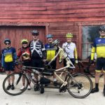
Another beautiful day! Porpoise Bay Provincial Park was my campsite and I got some pictures this morning. Not very full at all and a huge hiker / biker area. You can see there are a few other bicycle tourists. Pedaled out to the McDonalds in Sechelt for breakfast and wifi. Somehow my Garmin took a break there, so my ride is split into 2 segments; before and after McDonalds. I met 3 other bicycle tourists today. A guy from Canada and a couple from San Jose. All travelling at different paces, which is normal. We did catch the same ferry at Earl’s Cove however.
Today was not easy, at least until I get used to lugging my bike over any grade greater than 3%! Beautiful woodsy, mountain, lake, and ocean scenery to offset the effort. Having not done much research, I was happy to stumble onto the one and only hostel in Powell River. It was perfect, owned and run by a Swiss gentleman named Edwin. Having a very good Thai restaurant next door was a plus. I was pooped and decided to catch the second ferry at noon tomorrow to Campbell River.
The pictures: 17-07-14 – DAY 3 – SECHELT TO POWELL RIVER
The routes:
Day 3a – To Breakfast in Sechelt
Distance 3.36 mi | Time 20:20 | Speed 9.9 mph | Elevation 164 ft
Day 3b – Sechelt to Powell River
Distance 53.92 mi | Time 5:21:55 | Speed 10.1 mph | Elevation 3,901 ft
Day 4 – July 15th – Powell River to Campbell River
After breakfast nearby with another cyclist who was staying at the hostel, I checked out and caught the noon ferry to Comox on Vancouver Island. It’s a 1.5 hour trip. Then headed north and it was already getting late by the time I got to Campbell River. There were some nice bike paths on the way up and the road shoulder was plenty wide also. The tall skinny guy wood carving won first prize in a contest apparently. After a great salmon dinner I headed off for nearby Elk Falls Provincial Park. Got to the very woodsy campground and to my slight disappointment every single spot was taken. Well, it was Saturday night. By the way, this is a semi-primitive campground. There are outhouses with flush toilets, no sinks, no showers, various water bibs around the park.
I was starting to lose daylight and I wasn’t about to bike back to town. Surely I could find someone with an extra 15 square feet of space for me to pitch my tent. Also, no hikers or bikers here; all vehicles and RV’s. After being turned down several times I came across an interesting looking Volkswagen Vanagon with the top up. The owners were just out front at a water bib. Here were Max and Margaret from Switzerland, world travelers and two of the nicest folks you will ever meet. They welcomed me to their site, I got set-up just as it turned dark, and we had some good conversation. A picture of Max and the site were taken the next morning.
Distance 36.34 mi | Time 3:26:44 | Speed 10.5 mph | Elevation 928 ft
Day 5 – July 16th – Campbell River to Hoomac Lake
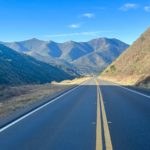
Today I overshot the runway, but luckily did not screw the pooch. After breaking camp and saying farewell to Max and Margaret I had a good breakfast at the appropriately named “Ideal Cafe” shortly after leaving the park. The road continued to be very good, but hilly, and the weather remains great. My problem was a lack of planning. I passed a campground just past Sayward, but thought this was a bit early. I checked one rest stop that had no water, only a toilet, so I assumed they were all like that. The road was beautiful, but very empty of facilities. If I was going to stop on the road, my only real requirement was water and I was almost empty on board.
Finally, after way too many miles, I stopped at a nice looking rest stop, and lucky me, the bathrooms had sinks with water! And picnic tables. I pitched my tent on a slightly tilted spot, fired up my stove and had some freeze dried soup and made tea. Some people earlier on had advised me that the local police don’t bother with this sort of illegal behavior this far north. I haven’t seen a cop in days and this road is very empty at night. All’s well that ends well. Pictures of my campsite at Elk Falls are included, but the roadside rest area campsite is in Day 6.
The pictures: 17-07-16 – DAY 5 – CAMPBELL RIVER TO HOOMAC LAKE
The route: Day 5 – Campbell River to Hoomac Lake
Distance 77.78 mi | Time 7:45:09 | Speed 10.0 mph | Elevation 3,967 ft
Day 6 – July 17th – Hoomac Lake to Port McNeill
After cooking up some breakfast and packing up, I bid farewell to the Hoomac Lake rest area. About 4 miles down the road is the berg of Woss with a motel, restaurant, gas station and convenience store, which is a lot more than I had heard was there. I ate another breakfast. Continuing north through the greenery and ever present headwind, I was starting to make a management decision.
The logistics of taking the ferry from Port Hardy to Prince Rupert are crummy as it leaves every other day and you have to be there at 5:30 AM. That is just an excuse. The real problem is my new lightweight equipment might not be all the rage. My sleeping bag seems too anxious to absorb moisture and I’m getting condensation inside of my tent. Perhaps I should have done a trial ride, preferably somewhere wet. In any case, I don’t fancy entering the real wilderness of northern BC and Alaska with sub-par equipment. After a rest day here in Port McNeill I am making a u-turn and heading for Victoria. Bright lights and Starbucks! It’s all good as I am revelling in my flexibility.
Future short term goals include southern Vancouver Island, maybe some of the Gulf Islands or San Juan Islands and a visit to my cousin in Port Townsend. Carry on.
The pictures: 17-07-17 – DAY 6 – HOOMAC LAKE TO PORT MCNEILLDAY 6 – HOOMAC LAKE TO PORT MCNEILL
The routes:
Day 6a – Hoomac Lake to Wossa – Hoomac Lake to Woss
Distance 4.31 mi | Time 21:55 | Speed 11.8 mph | Elevation 69 ft
Day 6b Woss to Port McNeillb Woss to Port McNeill
Distance 41.36 mi | Time 3:52:59 | Speed 10.7 mph | Elevation 1,640 ft
Day 8 – July 19th – Port McNeill – Sayward
After a rest day, I began my journey south on the same road that I came up two days ago. Well, you know it looks different in the reverse direction. This road is beautiful in either direction. Another pleasant day and I ate lunch in the same Korean restaurant in Woss that I had eaten breakfast in on the way north.
Made it to Sayward to a lovely campground with an attached hotel above the office. I felt really guilty about getting a very nice room with all the nice grassy spots for camping. I felt a lot better when it rained throughout the night and was still damp out in the morning. The only downside with this room was the very sketchy wifi.
The pictures: 17-07-19 – DAY 8 – Port McNeill to Sayward
The route: Day 8 – British Columbia – July 19th – Port McNeill to Sayward
Distance 82.47 mi | Time 7:00:47 | Speed 11.8 mph | Elevation 3,865 ft
Day 9 – Jul 20th – Sayward to Merville

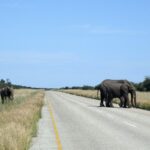
This was another beautiful day on Vancouver Island, a few clouds, a little drizzle, and great scenery running south on the main road, that I had come up a day or so before. The road is very well maintained with nary a pot hole and a decent shoulder. I didn’t want to take pictures of the same views, but I did manage to catch a few vultures and a logging truck that apparently dumps it’s load in the water. These are big trees, I’m not sure how old, and it seems a shame. I hope they are re-planting, they probably are, it is Canada. Then I think of all the copy paper I use and I do have an affinity for the use of toilet paper.
In Campbell River the main road branches and you can follow a more coastal route which I did in both directions. After a stop for lunch I continued onward. A little busy on this stretch of road, but most drivers are polite. A very cute and busy town of Courtenay is on the way.
A big shout out and thank you to one of my bicycling bros, Paul Nevins, who hooked me up with his cousin Ian in Merville. They live on a beautiful large farm. Ian and his wife Kris and kids and nephew and a recently arrived wwoofer from Germany (you’ll have to look that up), welcomed me warmly to their home to spend the night.
I’m not a foodie in general, but the meal we had was really over the top. Fresh caught red rock crab, humpback shrimp, rice, salad, and wine. After dinner a few of us went out and gathered raspberries from a nearby bush. These we had with ice cream, frozen yogurt and maple syrup. Oh my! I forgot to ask if this was their standard fare. Anyway, I was very impressed with this whole family, our conversation, and their lifestyle.
The route: Day 9 – BC – July 20th – Sayward to Merville
Day 10 – Jul 21st – Merville to Nanaimo
After a nice breakfast at Kris and Ian’s, I headed off with full rain gear into a steady, but not a downpour, of rain. I had bicycled from Victoria up to Comox back in the 80’s, but don’t remember a bit of it. One of the advantages of old age, combined with the changes on the road. Later in the day I removed most of the rain equipment, although intermittent drizzle continued. I managed a few photos, but admittedly I am a fair weather picture taker.
I passed through Qualicum Beach, a very busy resort town, which on a sunny day would have been a nice place to spend some time. I got to Parksville and landed at McDonald’s to explore the possibilities ahead on wifi. It took an inordinate amount of time on a busy Saturday to find a place to stay, but mission accomplished. It seems VIU, Vancouver Island University, in Nanaimo, rents out student rooms during the summer. This was quite a long day and I arrived just as the sun set (9:15 PM).
Great little room, rec room with TV (hello CNN), excellent wifi, and breakfast included. I’m staying two nights here and not bicycling tomorrow, just because I can.
Day 11 – July 22nd – Rest day in Nanaimo

A very pleasant day with no exercise at VIU in Nanaimo. After breakfast, I got my laundry done, did a little bicycle maintenance, watched a lot of CNN, and of course caught up on my blogging.
News flash! This place is overrun with bunnies. From about 20 miles out as I was bicycling here, I started to see them. At first, all I saw were very dark ones. Today at the university, the majority are dark, one I saw was white and another beige. They must be well treated around here, because they are not afraid of people.
The photos: 17-07-22 – Day 11 – Rest Day in Nanaimo
Day 12 – Jul 23rd – Nanaimo to Lake Cowichan
Another great day on Vancouver Island. After leaving the university I toodled through Nanaimo. It’s got some old historical buildings, but is more a transportation hub for the ferries. Spent a little time on the main route 19 which is like our limited access highways (like route 76). After Ladysmith, I took a bike route closer to the sea, less roaring traffic, but narrower roads as well. Went through the small towns of Chemainus and Crofton. I had already decided to do the Lake Cowichan – Port Renfrew loop on the way to Victoria when I stumbled upon a portion of the Trans-Canada Trail. Read about it in my photos.
This was really great. An old rail bed with grades no more than 1 or 2% and good for road bikes with nicely packed pea gravel. It’s very woodsy and shady which was good because it was getting hot. I biked with a local getting some exercise for about 5 miles. Took this for about 20 miles into Lake Cowichan. Had a nice dinner at Jake’s by the Lake. Weirdly, it was hard to get a good view of the lake from town. Off to my campsite a few klicks down the road.
Day 13 – Jul 24th – Lake Cowichan to Port Renfrew
Don’t cringe, but I have never eaten breakfast at A & W, but I did today because it was the only place open early. All I can say, it was a giant step up from McDonalds. Somehow when I try to charge my Garmin, it immediately creates a route up to that point. That is why I have a split record for today’s ride, albeit the first bit is tiny.
Today’s ride had no restaurants, towns, gas stations, nothing at all, until I reached Port Renfrew. What it did have was grand vistas of wooded mountains, rivers, and lakes. You can see the clear cuts and every know and then a huge full logging truck roared by, and the empties returned with the two trailers stacked on one another.
Halfway there the vegetation got lusher and greener. There is not much here, infrastructure wise. One very small market, a few restaurants, and some lodging for tourists. After I got my cabin, I made the mistake of biking to Juan de Fuca Park. I didn’t know that after the hilly 2 miles or so to the top, there was a nice loop hike down to the coast. I wasn’t about to leave my bike locked to a tree, so I biked down a very steep rocky trail to get some good views, but of course the sun was in exactly the wrong place. I walked most of the way back up and then the darn hilly paved ride back to home base. Shucks, I needed the exercise! Good dinner at the noisy Renfrew Pub.
Day 14 – Jul 25th – Port Renfrew to Sooke

Another beautiful sunny day. A good breakfast joint was right across the street from my cabin. The Canadians refer to eggs benedict as eggs benny and they are very popular. My cabin was barebones with a couple beds, a table, electricity, but no sink. The washroom was a very short walk away.
Shortly after leaving town the road tilted up and up forever. After the first mountain, there were several more and the gradients were steep, akin to De Luz in San Diego / Riverside counties. With my tonnage this was quite a challenge and the most difficult day so far. I guess I had pictured a flat coastal cruise along the straits of Juan de Fuca. Check out the profile. The pain was moderated by the splendid woodsy and ocean views and the flowers on the side of the road.
Made it to Sooke with a few good restaurants and a big flat campground by the Sooke River. Pictures of my campsite are included.
Distance 48.16 mi | Time 4:59:02 | Speed 9.7 mph | Elevation 3,219 ft
Day 15 – Jul 26th – Sooke to Victoria
From camp, I backtracked to Sooke for breakfast at Mom’s. Shortly after hitting the road I got onto The Galloping Goose. This a rail to trail that is just the cat’s meow. I won’t get into it here, but please google it if interested. It has a very interesting history. Like the other trail a few days ago it is nicely packed and very rideable pea gravel. The trail is only for bicycles, hikers, and horses. Only saw one horse rider, but many bicycles and a few walkers. I was on it for about 25 miles, the last 7 of which are paved, right into the city of Victoria. Mostly flat with some nice views, there were 2 very steep short dips and rises that I had to push the bike up. Surely the train had trestles over these back in the day.
Getting closer to the Victoria suburbs you can easily exit for lunch, which I did. The weather continues to be perfect and this was almost like a rest day. I checked into a hostel that I found online for the next 3 nights. I’ll have a few stories about this joint, and I use the term loosely.
The Pictures: 17-07-26 – Day 15 – Sooke to Victoria
Day 16 – Jul 27th – The Butchart Gardens
Finding a reasonably priced lodging for three nights in Victoria was a bit of a challenge, but I succeeded using the internet or so I thought. I booked a single room in a hostel thinking I haven’t stayed in one since Powell River and that one was nice. The location was fine. They were very full and the only room had NO WINDOW. This was probably akin to sleeping in a sauna. Maybe it was next to the boiler room, but I was in a third floor walk-up. Not only did I have to shlep my panniers upstairs, I had to do the same with my bike to the basement.
The next two nights I moved to a room with a window and everything was lovely. This was a very old building, the staff was nice, and they kept it clean. There was a bar that got quite raucous at night (lots of young kids, you know). One interesting feature was that they included an evening meal consisting of two bowls of several choices of a curry-like product with rice. You get in line and wait for your bowl to be filled. When it was my turn, I mentioned to the server that I was a very hungry bike rider and if he could add just a bit more. He gave me the stink-eye and reluctantly added a dollop of the gruel, which was pretty tasty.
If you are at all familiar with Seinfeld’s old show, you will know of “The Soup Nazi”. Honestly, this guy serving food resembled him in both looks and attitude. “No Soup For You!” I have a good chuckle when I think about this.
The Best of The Soup Nazi
Today I decided to re-visit The Butchart Gardens that I had been to about 35 years ago. It was another beauty of a day and I bicycled there. The ride north went up through Saanich on Lochside Regional Trail, another rail to trail configuration that went through woods, farmland, and by lakes, and later on surface streets over toward Brentwood Bay to the gardens. On the way there, I passed some giant hogs that someone had laid out cherries for, and it was fun watching them gobble up this treat and crunching them, pits and all.
You can see all of The Butchart Gardens in about a mile and a half of walking. It is very impressive to see what people can do with beautiful plants, landscaping, sculptures, and fountains. I nearly ran out of film. The bike ride back was on quieter surface streets until connecting with the Galloping Goose back to Victoria.
Day 17 – Jul 28th – Victoria Walkies

I decided to stay off of the bike today. Instead I did a walk around the environs, which included a long stretch along the harbor and by some of the more important buildings. This started by going through a small part of the beautiful Beacon Hill Park. Look up Terry Fox; he was quite a brave kid. Mile “0” is the beginning of the Trans-Canada Highway, Route 1. From the coast there were interesting snow covered mountain views of the Olympic Mountains and lots of fireweed covered banks leading down to the water.
Some of the highrise apartment buildings were works of art. There was a Fisherman’s Wharf, a tourist trap to be avoided. I say this because any place you have to stand in line to use the restroom should be shunned. At one end of it, there were some interesting homes right on the water. The big chain hotels were there as well as the classic Empress Hotel and the huge majestic Legislature Building. The totems were omnipresent and interesting.
Walking is difficult after your body is in tune with the bike. I did manage 5.5 miles.
Day 18 – Jul 29th – Victoria to Port Townsend, WA
Today I left Victoria on the 1.5 hour ferry to Port Angeles. Before I left I had time to pedal around a bit and got a picture of the entrance to Chinatown, and some clear pictures of the mountains in Olympic National Park. On the ferry I met several other bicycle tourists, Canadians and Germans. The first photo in Port Angeles is that tanker with snow covered Mount Baker to the right.
I soon got on the Olympic Discovery Trail, which is being worked on and extended. Right now it runs from just west of Port Angeles, through Sequim, and all the way to Old Blyn Highway, where you have to do some miles on 101. I then turned up toward Cape George and in a few miles I got on the Larry Scott Trail for part of the way to my cousin’s house.
This was another primo day and after getting settled in, I took some sunset shots from the back porch.
Day 19 – Jul 30th – Port Townsend
Today was the first of 3 rest days. I’m not that tired, but it is so nice here visiting with my cousin. I’ve been eating a lot and trying to get caught up on my blogging. Pictures are mostly of my cousin’s garden and sculptures. Then there was the concert in the park. Not quite an Oompah Band, but close enough. Port Townsend has it all!
The next you’ll hear from me is Day 22, Aug 2nd.
The pictures: 17-07-30 – DAY 19 – Port Townsend
Days 20 to 24 – Jul 31st to Aug 4th – Port Townsend to Port Angeles + Rest Days
My 3 planned rest days has turned into many more rest days and an aborted attempt to hit the road. A couple beautiful days after arriving in Port Townsend, the skies turned hazy from the smoke of the fires in British Columbia. In fact, a good chunk of Washington is covered in this. Apparently they had to evacuate 7,000 people up in BC.
After 3 days I decided to give it a go anyway and off I went back to Port Angeles, going on and off the Olympic Discovery Trail. The 50 mile ride didn’t seem to have any negative effects on me, but after checking the air quality numbers there and all along the Straits of Juan de Fuca, I thought it best to head back to Port Townsend to wait a few more days. I took a couple buses back the next morning.
My current plan is to head for the most westerly point of the lower 48 states in Cape Flattery and check out the area before heading south along the Washington coast. This smoke problem has given me two big fat reasons to apply the brakes. One, the health considerations. I have been watching the particulate monitoring stations register some unhealthy numbers, but now on Aug 4th they seem to be getting slightly better. Second, is the loss of the beautiful blue skies that I have been used to thus far, and the associated photo opportunities. I am a fair weather photographer after all.
Currently forecasting taking a bus back to Port Angeles and biking west from there starting Monday morning, August 7th.
Day 23 – Washington – Aug 3rd – Port Angeles to Port Townsend
Day 24 – Aug 4th – Walkies – Cape George
Electric Bike Toodle
Day 25 – Aug 5th – Around Port Townsend
A relaxing day with my Cousin-in-law visiting the Port Townsend Farmer’s Market and a drive onto Marrowstone Island and down to Beckett Point. Still hazy, so limited scenics. Later, after a meal at a Mexican joint, we drove down to Coyle to watch a great performance by this group; Welcome to the Official Sky in the Road Web Site
A very good day.
Day 26 was also a rest day. After more enjoyable rest days than I have ever taken on a bicycle tour, I finally hit the road. Since I had ridden Port Angeles to Port Townsend once in each direction already, I felt no guilt about biking into the town of Port Townsend and catching the bus to Port Angeles. From there west was a decent road although not always with a shoulder and a few logging trucks. Even though the air now was not unhealthy, there was limited ocean visibility which I know is very pretty. There is a foggy marine layer with the smoke hovering above.
I managed some road shots with a lot of fireweed. This is an omnipresent plant, and interestingly it likes to grow in places that have been disrupted, such as with clear cutting by the logging industry. I found a nice little campground in Clallam Bay and dinner at the eclectic co-op as the fog settled in for the evening.
Day 28 – Aug 28th – Clallam Bay to Forks

The day started by breaking camp with my sopping wet tent from dew and heading west. In a short while I stopped in Sekiu for breakfast. Continuing through some beautiful forest with glimpses of the foggy coast here and there. On the edge of Neah Bay, I visited the Makah Museum. Very well done, I spent several hours here. This tribe has an oral history dating back 500 years! I found it interesting that there was no mention of what we now know about the migration of people across the Bering Strait from Asia.
After lunch I continued to Cape Flattery, the furthest west point of the contiguous United States, or lower 48. The closer I got the foggier it became. At the trailhead I hid my bike in the woods out of sight and locked it to a tree. The one mile hike through the woods to several overlooks was really worth the price of admission. (It was free). A little disappointed with the fog, I did manage some photography, but the views were not optimal. The place is gorgeous.
It was getting late by the time I got back to Neah Bay and I decided to hop a bus to Forks, thereby avoiding some riding in the mist the next morning. The driver let me load my heavy bike right onto the bus rather than the rack in the front. There was only one other passenger anyway. It was getting toward sunset and this bus driver dropped me off at an RV park 8 miles short of Forks, where he knew I could camp because he lived there in a doublewide. What a guy! One of his neighbors made me a bowl of soup while I put up my wet tent. Some very nice folks out here in the sticks.
Day 29 – Aug 29th – Forks to Ruby Beach
Another foggy and dewy morning to start my ride with a very wet tent. Stopped in the nice town of Forks for a long breakfast. I wanted to stop somewhere early to let my tent dry out, when I ran across the Rain Forest Hostel, video tour of the Rain forest hostel near forks washington. You can use this to visit Ruby beach, La Push, Forks…
I won’t say this guy running it is a whack-a-doodle, but there are a few cards missing from his deck. The place had several very eclectic visitors, from a New York City high school principal to a few semi-homeless souls. In any case, my tent dried out in the sun and I camped in his yard. I also did a little spin down to Ruby Beach, where most of the photos were taken.
One of the guests actually whipped up some dinner for a few of us there early and I did the dishes. It was a very pleasant stay.
Day 30 – Aug 10th – Ruby Beach to Amanda Park
One of the guests at the hostel provided some toast and I brought some tea. Tent wet again; after all, this is near the wettest place in the United States. I tootled off down 101 where it remained foggy and cool with some limited views of the Washington coast. I made it to Quinault along a beautiful river and throngs of tourists. Not a room or tent site to be had. I backtracked to Amanda Park and found a room and my camping gear dried out nicely in the room.
Day 31 – Aug 11th – Amanda Park to Hoquiam
The towns of Hoquiam and to a lesser extent Aberdeen have seen better days. Lots of boarded up businesses, including hotels and restaurants. Although I saw plenty of logging trucks, apparently not enough to support the local economy as in the past. I did find a Starbucks in Aberdeen before finding a room in Hoquiam. Gave the camera a rest today.
Day 32 – Aug 12th – Hoquiam to South Bend
I found a “warmshower” in South Bend. Super nice couple recently moved from Seattle, living in a great old house overlooking the bay. See picture. The day was flattish. Did a little detour through the town of Westport, a half-baked resort and fishing village. The coast road south from there provided zero views of the ocean until it turned east along the bay. An Indian casino and some farmland were the highlights.
Day 33 – Aug 12th – South Bend to Warrenton, OR
I bid farewell to my hosts in South Bend, (see picture), and continued my journey south. Made it into Oregon over the crazy 4 mile long causeway and steep final bridge over the Columbia River into Astoria. It was another nice day, partly cloudy. Astoria was very busy and the motels were very happy with Motel 6 charging $155 a night as an example. After dinner at the Pig and Pancake, I headed over to Warrenton and Fort Stevens State Park, which had the first of many “hiker / biker” campsites in Oregon. For $6 you can camp and have a hot shower. Magnifico!
Day 34 – Aug 14th – Warrenton to Nehalem Bay
Had one of the best breakfasts ever at Arnie’s in Warrenton on the way out. A very pleasant day, although a little noisy on route 101. Went through Seaside and then the very touristy and pretty Cannon Beach, after which the scenery got serious. “Haystack Rock” is the giant stack near Cannon Beach. After this the road had a lot of hills with some great vistas as I approached Manzanita. Staying at another “hiker / biker” area in Nehalem State Park.
Day 35 – Aug 15th – Nehalem Bay to Garibaldi
After a nice breakfast at Wanda’s in Nehalem Bay, I hit the road. I’m having a good run of weather for which I am grateful. Rockaway Beach had an old steam engine making a tourist run back and forth to Garibaldi. There are tracks along this stretch that run for miles and were used back in the day for the logging industry.
I felt the need for TV, a bed, and wifi, so I got a motel room in Garibaldi after a pretty short day. Did my laundry in the sink in the room and the nice workers at the motel did the drying in their facilities. Dinner was had in a restaurant next door.
Day 36 – Aug 16th – Garibaldi to Cape Lookout

Day 37 – Aug 17th – Cape Lookout to Lincoln City
Surprisingly, it was a dry morning at Cape Lookout State Park in the woods next to the ocean. The beginning ride from here was up a giant hill that topped out at the actual Cape Lookout. Continuing on the “3 capes loop”, the town of Cape Kiwanda was cute and hopping with tourists and then the less touristy and bigger Pacific City. I did a recommended side route loop east of Route 101 on Slab Creek Road. This was very quiet and went into a National Forest and quite a climb. On the way out, I stopped at the Otis Cafe in Otis as advised by a fellow camper, who I had met in the Cape Lookout campground. Their specialty is home fries smothered in cheese and onions. Quite tasty along with a giant hamburger. The hiker / biker area at Devil’s Lake State Park was a bit of a pit on the edge of Lincoln City with a few unsavory characters.
Day 38 – Aug 18th – Lincoln City to Newport

In the morning as I was packing up my very wet tent fly and getting ready, a lady from the regular camp sites walks over, starts a conversation, and invites myself and Joe, the other bicycle tourist from the previous night, to breakfast. She was from Spokane, had done some bicycle touring, and was camped with her family. Her hubby whipped up pancakes and sausage and hot chocolate. Unbelievable generosity from a very nice family that had lost their home during the downturn in real estate.
This was another bluebird day. Part of the short ride today was off of the 101 and designed for viewing the coast. I had a nice break in Depoe Bay and checked into a motel at the north end of Newport.
Day 39 – Aug 19th – Newport to Florence
Breakfast at the Newport Cafe – not recommended. Pancakes tasted like bisquick. I hate to get repetitive, but this was another picture perfect day. Good temps with a tailwind. Big hills near Cape Perpetua and gusty winds had me holding tightly to my handlebars. Lucky my bike is so heavy, even a motorcyclist was complaining about almost tipping over. In Florence I checked into the No-Tell Motel and immediately felt like death warmed over. I was achy and definitely had a fever. All I could do was lay there and watch CNN, not even enough energy to eat dinner! Took a few baby aspirin and hit the hay.
The fever broke in the middle of the night and I was fine the next morning. I decided to stay another day, just in case. Trying to figure out what happened to me. My first thought was the pancakes yesterday morning, but my digestive tract was fine. The motel front desk guy, who was very nice, suggested the mold from all the forest area I was riding through. Shortly thereafter, I realized I had not been taking proper care of my water bottles (and I’m carrying a bottle brush) and the sugar from my gatorade was acting like a petri dish for bacteria. Anyway, that’s my guess and I’m sticking to it.
My immune system must be on fire because I have no lingering effects. I’d be interested to hear what my smart friends and relatives think about this.
Day 41 – Aug 21st – Florence to North Bend
Before leaving Florence, I caught a glimpse or two of the eclipse with some folks at the motel using their protective glasses. Probably had about 95% coverage of the sun. The automatic street lights went on. I understand the rarity of a total eclipse in North America, but I’m much more excited about how much we actually know about our universe, like the earth’s age of 5 billion years and the cosmos at 15 billion years, give or take. The math and science knowledge that allows astronomers to know precisely where and when these events will occur is mind boggling. I can only imagine what our Neanderthal ancestors thought when the sun got blotted out. Back to my tour….
The ride to North Bend was all on 101, with a decent shoulder, but lots of traffic heading away from the eclipse totality. This was mostly through the Oregon Dunes area which you only see glimpses of unless you take roads off toward the coast, which I did not. I might be a little jaded of seeing sand dunes after spending a few years in Saudi Arabia. The bridge pictured is the one I will be taking tomorrow over the bay and into the main part of North Bend. I found a nice motel and a nearby very good restaurant, Hilltop House, for dinner.
Day 42 – Aug 22nd – North Bend to Bandon
Over the bay bridge, to the main part of North Bend, breakfast at Tai’s, wound my way over to Coos Bay, through Charleston, and onto Seven Devils Road. I remember this area from when I biked it in year’s past. A little hilly, but quiet, when compared to Highway 101. Some bay views and forests with clear cuts, but not as colorful and fabulous as further north.
Staying in a nice motel in Bandon and had an Italian meal at a restaurant owned and run by an Italian immigrant.
Day 43 – Aug 23rd – Bandon to Gold Beach

Started out with some coastal fog on a scenic loop out to the coast of Bandon. I wish I had gone out there yesterday when it was bright and sunny. The coast of Oregon is wonderfully rugged in many areas. Today’s ride caught some of that. Route 101 was a little rolly with a decent shoulder and some great view points.
The whole day I was fretting about the huge fires burning just inland from where I was heading. I told myself I would stick out my thumb as soon as the air was smoky. It never happened all the way to Gold Beach. I hear things south of here are much worse along the coast. I leave the hitching option open. I’m in a motel again tonight and I like it!
Day 44 – Aug 24th – Gold Beach to Crescent City, CA

The first half of the day was very nice, evidenced by the photos of the rugged coast. Just as I entered Brookings, the smoke in the air was more pronounced and I could feel it most in my eyes. The smoke forecast heading south isn’t real promising. The fire in Oregon is huge and there are several smaller ones in California.
The good news is that I made it to California. The rest of the day was uneventful, but got quite cool as I rode through a gauntlet of trees and to the coast in Crescent City. I found an acceptable motel room on the south end of town. You may have noticed that I am staying in a lot of motels. I will talk more about this later.
Day 45 – Aug 25th – Crescent City to Orick
For some reason I felt a little exhausted this morning, but that didn’t deter me from the biggest climb of the trip so far, just south of Crescent City. Lots of ongoing road repair on this section of 101, which climbs through some beautiful redwoods. Not a lot of shoulder here either, so not many photo ops. Later, I entered the Del Norte section of the Redwood State and National Parks.
After several more hills, there is an alternate route, Newton B. Drury Scenic Parkway, that parallels the 101, and after a stiff climb, it meanders downhill for many miles through the most magnificent forest of redwoods. These trees are divine and must be seen in person to get the full impact. They are too big to be captured properly with a camera. Mixing nature and archaeology, I rank this experience, which I have done several times now, right up there with exploring the pyramids of Giza near Cairo. Really!
Later found a funky old room next to an equally funky cafe in the run down town of Orick.
Day 46 – Aug 26th – Orick to Arcata
The day started out looking very smoky and I was contemplating taking a bus, which didn’t come by until late in the afternoon. I started pedaling and as happens most of the time, things got better. After some good hills on 101 I got to Trinidad, a very lovely area with great coastal scenery. I could hear seals barking for awhile before I found a viewpoint where I could see them in the distance.
After Trinidad I got on the limited access Hammond Trail for most of the way to Arcata. I’m staying at the Redwood Lily Hostel in a great century old building for two nights.
Day 47 – Aug 27th – Rest Day in Arcata
I didn’t do much today….hence the name “rest day”. Did a very short walk around downtown Arcata. The town itself is a little moth-eaten. It’s way past it’s heyday and I didn’t see any big efforts to spruce it up. I sensed some poverty and a drug culture. It is the home of Humboldt State University, which I did not go through, so there are many students all over the place. There was one very expensive and upscale market, I suppose taking advantage of the student’s parent’s money. There was a Safeway there also, less expensive.
The highlight for me was my stay at the eclectic Redwood Lily Hostel. Not a typical hostel, with the dorm rooms being much more spacious and fewer beds, two kitchens, good wifi, and a nice vibe. I met folks from Argentina, Italy, Panama, Ireland, and Mexico.
Later that day, I had a nice visit from a not so old bicycling bud, Joe Vogelpohl who was on his way home, just north of here. We had dinner together….good times!
Day 48 – Aug 28th – Arcata to Myers Flat

I took the long way and less busy way out of town around Arcata Bay, through Manila, and into Eureka. Got a picture of the obviously renovated Center for the Performing Arts, maybe the best looking building in busy Eureka. I finally found an AAA office to get some decent maps. After this I was mostly on 101. I stopped in Fortuna for a break before getting on The Avenue of the Giants. This is the Humboldt County section of the fantastic redwoods. Like I said before, you have to experience them in person. They are magisterial!
I ended up camping for the first time since Lincoln City, OR in Hidden Springs Campground in Humboldt Redwoods State Park. It was pleasant and notably dry.
Day 49 – Aug 29th – Myers Flat to Leggett
Thankfully a dry morning to start down through the remainder of the Avenue of the Giants. This section of 101 is inland and separated from the ocean by some big hills. It can get stinking hot and it was on. There is a big hill up to Garberville, which has basic services, but not a place you’d want to retire. It’s kind of a stinker. There is something about Humboldt County that does not please me, except of course the great redwood forests.
After Garberville the hills got bigger and it was in the high 90’s with very little shade. Following the south fork of the Eel River there was finally some shade relief in the Smith Redwoods State Reserve, and finally a few miles from Leggett I got to Standish-Hickey State Recreation Area with a hiker-biker area. A place across the street provided minimal groceries and some good sandwiches and most importantly wifi. Now I am in Mendocino County and all is well. There were about 6 other cyclists in the campground which was amazingly empty. Further north, most campgrounds were very full. Kids are back in school now.
Day 50 – Aug 30th – Leggett to Fort Bragg
From the frying pan into the refrigerator, but not for long. Leaving from another dry morning in camp, a little food and coffee at the convenience store and then the climbing began. This is the junction from 101 onto Route 1 over to the coast. Couldn’t wait to get out of this very hot valley. It’s a very nice, although twisty road through forest. It climbs forever….check the profile. The downhill portion goes on for much longer than the uphill! The temperature actually got down to the low 50’s, and that’s not including the wind chill! After a final annoying climb, allowing me to thaw out, you drop onto the coast.
A little foggy at first, it cleared beautifully, and contrary to popular belief, the coast is not all downhill, but a roller coaster with pretty solid grades as well. The first stop, where I met up with 3 other bicyclists from the previous camp was in Westport, where an excellent sandwich was made by the proprietor in the only store for miles.
Rolling along the coast was pleasant and I made it to Fort Bragg and checked into the Motel 6. Thankfully this was Thursday, before the big Labor Day weekend. The weekend rates here will be over $200 per night in the freaking Motel 6! Gag me with a spoon!
Day 51 – Aug 31st – Fort Bragg to Manchester

It was a pretty nice roller coaster of a day down the Mendocino Coast. A few good vistas, some pink lilies, and moderate temperatures. Because I started a few hours later than usual, due to good wifi at David’s Deli in Fort Bragg, I only made it to Manchester State Beach, which would have had a hiker-biker area if it were open. Closed due to the endangered Point Arena Mountain Beaver, although I blame it on Trump. This day included going through the very cute and historic town of Mendocino.
There was a KOA right next to the park which turned out to be a very nice place to camp. They had some frozen things to microwave for dinner and other sundry items and most notably decent wifi.
Day 52 – Sep 1st – Manchester to Stillwater Cove
Who let the dogs out? All of a sudden the heat is back on. The inland areas are really cooking if it is in the 90’s here! The skies are smoky too due to fires in California inland from the coast. It is messing with my photo efforts. I don’t feel it, but it certainly isn’t ideal riding conditions. And cars are flocking north on holiday. It’s really a shame. Short day due to excessive heat.
Today I crossed from Mendocino to Sonoma County. I’m thankful now that I still have my camping gear, because there isn’t a room to be had. Staying in yet another hiker-biker area of Stillwater Cove State Park.
Day 53 – Sep 2nd – Stillwater Cove to Samuel Taylor
This was a pretty hard, hazy, hot, humid, heck of a day. Every day of adventure touring can’t be all fun and games. There were lines of traffic mostly going north that were miles long in some places. My big concern was that there were no rooms anywhere and regular campgrounds were totally full. My best option was to make it to Samuel Taylor State Park which has a hiker-biker area where bicyclists always are provided a campsite. In fact they opened up 4 areas for bicyclists. Gotta love long holiday weekends!
The heavy traffic and a lot of no shoulder road had me staying very alert and (Miss Judy would be very proud) practicing my defensive bicycling techniques.
I went by historic Fort Ross and had a nice break on Bodega Bay at an air conditioned restaurant in sort of a mall right on the bay. It’s funny, but there are not many businesses with air conditioning in this part of the world. It just doesn’t usually get this hot. Entered Marin County and some nasty hills after Tomales with a final hump from Olema over to Samuel Taylor State Park which is quite nice in the redwoods.
Day 54 – Sep 3rd – Samuel Taylor SP to Corte Madera
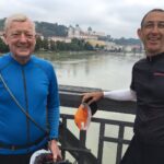
Still hot today, but a tad better than yesterday. Made the 10 miles into Fairfax, one of my favorite towns. Had a good late breakfast at the Barefoot Cafe and then went over to everyone’s favorite coffee joint, The Coffee Roaster. Here I made a connection with Bill Dunn, an old bicyclist friend and tour leader par excellence.
He was gracious enough to escort me on a neat low traffic route to Corte Madera where my only desire was an air conditioned room with all the creature comforts after my last 3 nights of camping. This gets me caught up on my blog and more importantly, my laundry. A great short day.
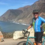
Day 55 – Sep 4th – Corte Madera to Montara
Today was a trial by haze and wind. And when I say haze, I mean smoke. Not the kind of smoke that makes you cough and your eyes burn, but the kind that covers hundreds of square miles and mutes the colors and hides the skyline. It was not an interesting experience going over the Golden Gate with 30 mph gusts of wind and absolutely no view of the San Francisco skyline. I’m thankful that I have seen it in pristine conditions in the past.
As I headed south the wind was directly in my snout, hence my impressive 6.9 mph average. At least the temperatures were much better today, mostly in the 70’s. Later in the day, conditions improved slightly and I took pictures. I hovered along the coast, on the outskirts of Daly City and then Pacifica. I went through the fairly new tunnel at Devil’s Slide which was surprisingly nice with a good bike lane and dropped into Montara, where I am staying at the Lighthouse Hostel, located on a cliff above the ocean. I actually have an ocean view from my room.
Day 56 – Sep 5th – Montara to Santa Cruz
Today was not my finest hour. I knew the wind forecast was not favorable. It wasn’t an exceptionally hilly day, might have been better if it was. It’s a weird thing about bicycling (or maybe it’s just me), a steady headwind on a flattish road is much harder (on the mind) than a hilly day with a headwind.
The direct headwind was maybe 8 to 10 mph, with gusts up to 15 I’m guessing. Anyway, after many starts and stops and self-commiseration, I stuck my thumb out after 30 miles and almost immediately got a ride with a fellow in a pick-up truck going to Santa Cruz where I had a motel reservation. I was knackered and happy as we rolled over some good sized hills and into town. He was quite impressed with the weight of my rig as it took two of us to get it in and out of his truck.
Tonight I’m re-thinking my options as the wind forecast is from the south for the next several days and we believe the weatherman don’t we?
Day 57 – Sep 6th – Santa Cruz to Salinas
Decision made last night. Catching an Amtrak train in Salinas to take me home. Between the wind and the fog, my funmeter is registering a very low score. I even made a warmshower connection in Salinas with a very nice couple. The ride to Salinas was pleasant and uneventful. Went through Capitola, Aptos, Elkhorn Slough, and stopped in Castroville for lunch. Also went by many acres of farmland that looked very productive.
Salinas looks like a nice little berg to spend some time….next time.
Day 58 – Sep 7th – Salinas to Oceanside
After a little toodle around Salinas, I went to the train station early to check the schedule of the Coast Starlight which has a spotty on-time schedule. Sure enough, the agent said it would be at least 2 hours late! Even if it would be on time, the connection in Los Angeles would have gotten me to Oceanside at midnight. This was now off the table. Then the agent tells me that there is an Amtrak bus leaving from here in about 10 minutes to San Luis Obispo and would I like to get on it? There would be a connecting Pacific Surfliner train there, getting me into Oceanside at 9:30 PM. Of course…let’s do it!
I was picturing a ratty old seat stained Greyhound when this brand new beautiful bus pulls up. Apparently, Amtrak contracts with this company to provide connections between some of it’s stations. It was comfortable, smooth, fast, and had wifi. I must be living right!
Got to Oceanside, missed the last train inland, and biked the last 8 miles home, using my headlight for just the second time on the whole trip. The first time was on Day 0, in Vancouver, BC when I arrived there pretty late.
This was another great bicycle tour. I have to say that I haven’t been on a bicycle tour that wasn’t wonderful. You don’t have to have super human strength. You do need the time, proper equipment, and bicycling experience to make it enjoyable. The expense is much less than most other types of travel. Even with my change of plans, directions, headwinds, and smoke from fires chasing me, it had little effect on the overall fun of the trip.
Some points of interest for those who might be interested; My 1981 Merz bike performed well. I did a little front wheel truing in Oregon. My front derailleur was sticking a bit, but a little chain lube fixed that. My Schwalbe Marathon Plus tires performed flawlessly….no flats! From the included spreadsheet, I went 2,171 miles in 59 days or an average of 37 miles per day, and about 47 miles per actual travel day. It seems, almost every tour that I have taken with full camping gear I have averaged about 1,000 miles per month. I slept in my tent 17 out of 59 nights or 29% of the time. I sent home about 8 pounds of stuff from Washington, including a stove, fuel, small pot, some warmer clothes, and other miscellaneous items. I used my rain gear, consisting of gloves, jacket, pants, and booties, only once for a couple of hours on Vancouver Island.
There you have it! Hope you had fun following along. Please let me know if you have any comments or questions….
Burt
Day 58 – Sep 7th – Part 1 of 2 – Salinas
Day 58 – Sep 7th – Part 2 of 2 – Oceanside
The full itinerary spreadsheet: BC + WEST COAST 2017 – ITIN.xlsx

